Classical Dances of India

Only Eight Indian dance forms are recognised with classical status by The Sangeet Natak Akademi.
  1. Bharatanatyam - originating in Tamil Nadu
  2. Odissi - originating in Orissa
  3. Kuchipudi - originating in Andhra Pradesh
  4. Mohiniaattam - originating in Kerala, performed by women
  5. Sattriya - originating in Assam, conferred classical status most recently
  6. Kathakali - originating in Kerala, performed by men
  7. Kathak - originating in Northern Indian
  8. Manipuri- originating in Manipur

Other art dances yet to be conferred as classical dances
  1. Gaudiya Nritya - Bengali art dance
  2. Andhra Natyam - Telugu art dance
  3. Vilasini Nrityam/Natyam - Telugu art dance
  4. Kerala Natanam - Kerala classical dance

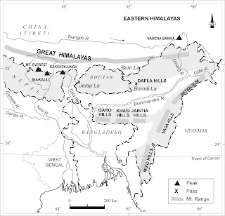
Map of North Eastern India

Map of North Eastern India

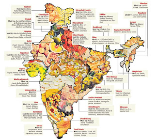
Food Map of India

Food Map of India
Food Map of India

General Studies 2012 Mains Syllabus pdf free download

GENERAL STUDIES

General Guidelines:
The nature and standard of questions in the General Studies papers will be such that a well-educated person will be able to answer them without any specialized study. The questions will be such as to test a candidate’s general awareness of a variety of subjects, which will have relevance for a career in Civil Services. The questions are likely to test the candidate’s basic understanding of all relevant issues, and ability to analyze, and take a view on conflicting socio-economic goals, objectives and demands. The candidates must give
relevant, meaningful and succinct answers.

PAPER - I


1. History of Modern India and Indian Culture :
The History of Modern India will cover history of the Country from about the middle of nineteenth century and would also include questions on important personalities who shaped the freedom movement and social reforms. The part relating to Indian culture will cover all aspects of Indian culture from the ancient to modern times as well as principal features of literature, arts and architecture.

2. Geography of India :
In this part, questions will be on the physical,economic and social geography of India.

3. Constitution of India and Indian Polity:
This part will include questions on the Constitution of India as well as all constitutional, legal, administrative and other issues emerging from the politico-administrative system prevalent in the country.

4. Current National Issues and Topics of Social Relevance :
This part is intended to test the candidate’s awareness of current national issues and topics of social relevance in present-day India, such as the following:
(i) The Indian economy and issues relating to planning, mobilization of resources, growth, development and employment.
(ii) Issues arising from the social and economic exclusion of large sections from the benefits of development.
(iii) Other issues relating to the development and management of human resource.
(iv) Health issues including the management of Public Health, Health education and ethical concerns regarding health-care, medical research and pharmaceuticals.
(v) Law enforcement, internal security and related issues such as the preservation of communal harmony.
(vi) Issues relating to good governance and accountability to the citizens including the maintenance of human rights, and of probity in public life.
(vii) Environmental issues, ecological preservation, conservation of natural resources and national heritage.

PAPER - II

1. India and the World :
This part will include questions to test candidate’s awareness of India’s relationship with the world in various spheres such as the following:-
Foreign Affairs with special emphasis on India’s relations with neighbouring countries and in the region.
Security and defence related matters.
Nuclear policy, issues, and conflicts.
The Indian Diaspora and its contribution to India and the world.

2. India’s Economic Interaction with the World :
In this part, questions will be on economic and trade issues such as foreign trade, foreign investment; economic and diplomacy issues relating to oil, gas and energy flows; the role and functions of I.M.F., World Bank, W.T.O., WIPO etc. which influence India’s economic interaction with other countries and international institutions.

3. Developments in the Field of Science & Technology, IT and space :
In this part, questions will test the candidate’s awareness of the developments in the field of science and technology, information technology, space and basic ideas about computers, robotics, nanotechnology, biotechnology and related issues regarding intellectual property rights.

4. International Affairs and Institutions :
This part will include questions on important events in world affairs and on international institutions.

5. Statistical analysis, graphs and diagrams :
This part will test the candidate’s ability to draw conclusions from information presented in statistical, graphical or diagrammatical form and to interpret them.

Download pdf file
(Go to File menu and click on save)

Wetland, Swamp, Marsh, Bog, Fen and Mangrove

A wetland is a land area that is saturated with water, either permanently or seasonally, such that it takes on characteristics that distinguish it as a distinct ecosystem. The water found in wetlands can be saltwater, freshwater, or brackish.

There are four major kinds of wetlands: swamps, marshes, bogs and fens.

A swamp is a wetland that is forested.
Swamp
Swamp

 
A marsh is a type of wetland that is dominated by herbaceous rather than woody plant species
Marsh
Marsh

 
A bog is a wetland that accumulates peat, a deposit of dead plant material—often mosses, and in a majority of cases, Sphagnum moss.
Bog
Bog


A fen is one of the four main types of wetland, and is usually fed by mineral-rich surface water or groundwater.


Mangroves are various kinds of trees up to medium height and shrubs that grow in saline coastal sediment habitats in the tropics and subtropics – mainly between latitudes 25° N and 25° S
Mangrove
Mangrove

The Tiger population estimation procedure of India

The current tiger estimation is based on the established scientific methods. The earlier pugmark counting method was considered flawed because of the inflated number of tiger population.

The present scientific tiger estimation procedure involves rigorous statistical analyses. The statistical data is obtained in three phases and involves ground surveys, analyses of satellite data and camera traps.

The three phases of the Tiger Estimation Procedure

Phase I: Ground survey data at the beat level was collected by field personnel in a standardised protocol after training.

Phase II: Statistical and satellite data were analysed by the Wildlife Institute of India in collaboration with the National Tiger Conservation Authority.

Phase III: The camera trapping procedure was conducted by research biologists.

The population of the tiger was estimated in 17 Indian states. The results from this procedure indicate that tiger populations are viable within Protected Areas but are under threat outside them.

This data is a crucial component of Project Tiger and is used to:
  • Measure the present status of tiger populations across the 17 tiger States in the country.
  • Develop effective strategies to strengthen future tiger conservation programs.
Source: http://moef.nic.in/downloads/public-information/Tiger%20Estimation.pdf

National Waterways of India

Inland Waterways Authority of India (IWAI) was created in 1986 for development and regulation of Inland Waterways for shipping and navigation. The Authority undertakes the development and maintenance of Inland Waterways.

National Waterway 1 :
Allahabad–Haldia stretch of the Ganges–Bhagirathi–Hooghly river system.
Estd = October 1986. Length = 1620 km

National Waterway 2
Sadiya — Dhubri stretch of Brahmaputra river.
Estd = September 1982. Length = 891 km

National Waterway 3
Kottapuram-Kollam stretch of the West Coast Canal, Champakara Canal and Udyogmandal Canal.
Estd = February 1993 Length = 205 km

National Waterway 4
Kakinada–Pondicherry stretch of Canals and the Kaluvelly Tank, Bhadrachalam – Rajahmundry stretch of River Godavari and Wazirabad – Vijayawada stretch of River Krishna.
Estd = November 2008 Length = 1095 km

National Waterway 5
Talcher–Dhamra stretch of the Brahmani River, the Geonkhali - Charbatia stretch of the East Coast Canal, the Charbatia–Dhamra stretch of Matai river and the Mangalgadi - Paradip stretch of the Mahanadi River Delta.
Established = November 2008 Length = 623 km


Source : http://www.iwai.nic.in/index1.php?lang=1&level=1&sublinkid=124&lid=143

WWF Priority species of India - Lesser known species

http://www.wwfindia.org/about_wwf/priority_species/lesser_known_species/

Fishing Cat
Fishing Cat

Ganges Shark
Ganges Shark

Great Indian Bustard

Himalayan Quail
Himalayan Quail

Hoolock Gibbon
Hoolock Gibbon

House Sparrow
House Sparrow

Kaiser-i-Hind butterfly

Nicobar Pigeon
Nicobar Pigeon

Olive ridley Turtle
Olive ridley Turtle

Chinese Pangolin
Chinese Pangolin

Purple Frog - Nasikabatrachus sahyadrensis

Rameshwaram Ornamental Spider

Red Line Torpedo Barb

Sarus Crane
Sarus Crane

Slender Loris
Slender Loris

White Winged Wood Duck


http://www.wwfindia.org/about_wwf/priority_species/lesser_known_species/

WWF Priority species of India


Asiatic Elephant
Asiatic Elephant

Asiatic Lion
Asiatic Lion

Bengal Tiger
Bengal Tiger

Black Necked Crane
Black Necked Crane

Gharial
Gharial

Nilgiri Tahr
Nilgiri Tahr

Great Asian One-Horned Rhino

Red Panda
Red Panda

Smooth coated Otter
Smooth coated Otter

Snow Leopard
Snow Leopard

Snow Leopard
Ganges River Dolphin © François Xavier PELLETIER/WWF-Canon


Draft National Water Policy 2012 Document Free Download

Draft National Water Policy 2012 Document Free Download

Click here to download

Water in Indian Constitution

The Constitution of India lays down the legislative and functional jurisdiction of the Union, State and local Governments regarding 'Water'. 

'Water' is basically a State subject and the Union comes in only in the case of inter- state river waters.

List II of the Seventh Schedule, dealing with subjects regarding which states have jurisdiction, has the following as Entry 17 : "Water, that is to say, water supplies, irrigation and canals, drainage and embankments, water storage and water power subject to the provisions of Entry 56 of List I 

Entry 56 of List I (Union list), reads as follows: "Regulation and development of inter- state rivers and river valleys to the extent to which such regulation and development under the control of the Union, is declared by Parliament by law to be expedient in the public interest".

The Constitution has a specific article (Article 262), dealing with adjudication of disputes relating to matters of inter- state rivers or river valleys, which reads as follows: 
Article 262 
  1. Parliament may by law provide for the adjudication on any dispute or complaint with respect to the use, distribution or control of the waters of, or in, any inter- state river or river valley.
  2. Notwithstanding anything in this Constitution, Parliament may by law provide that neither the Supreme Court nor any other Court shall exercise jurisdiction in respect of any such dispute or complaint as is referred to in clause (1).

The recent 1992 amendments to the Constitution regarding Panchayats and Municipalities introduced the following entries in the schedules listing the subject-areas in which the State Governments and legislatures may devolve functions to such bodies, so as to make them evolve as local self-governing institutions: 

In the Eighth Schedule (Part IX) dealing with Panchayats, the subjects, ''Minor irrigation, Water management and Watershed development", "drinking water" and "maintenance of community assets" are listed.

In the Twelfth Schedule (Part IX A) dealing with municipalities, the subjects "water supply of domestic, industrial and commercial purposes" is listed. Functional responsibilities are, thus, visualised for local Governments in respect of several aspects of water use.

The two laws enacted by the Union under Article 262 and Entry 56 of List I are the Inter-State Water Disputes Act, 1956 (as amended up to 1980) and the River Boards Act, 1956

In recent years since the Constitution does not have an entry relating to 'Environment', using the residual powers, the Union has enacted laws on environment and control of pollution, which have effect on water use including ground water and its exploitation. A large number of Acts dealing with irrigation, canals and their maintenance, water rates and cess, command area development and maintenance of tanks are in force in each state. Some of the Acts are as old as the 1860s and 70s.

Catchment Area, Drainage basin, Watershed and River basin

A river drains the water collected from a specific area, which is called its ‘catchment area’.

An area drained by a river and its tributaries is called a drainage basin. The boundary line separating one drainage basin from the other is known as the watershed.

The catchments of large rivers are called river basins while those of small rivulets and rills are often referred to as watersheds.

There is, however, a slight difference between a river basin and a watershed. Watersheds are small in area while the basins cover larger areas. River basins and watersheds are marked by unity. What happens in one part of the basin or watershed directly affects the other parts and the unit as a whole. That is why, they are accepted as the most appropriate micro, meso or macro planning regions.

Lakshadweep and Minicoy Islands of India

The islands of the Arabian sea include Lakshadweep and Minicoy. These are scattered between 8°N-12°N and 71°E -74°E longitude. These islands are located at a distance of 280 km-480 km off the Kerala coast.

The entire island group is built of coral deposits. There are approximately 36 islands of which 11 are inhabited. Minicoy is the largest island with an area of 453 sq. km. The entire group of islands is broadly divided by the Eleventh degree channel, north of which is the Amini Island and to the south of the Canannore Island.

The this archipelago have storm beaches consisting of unconsolidated pebbles, shingles, cobbles and boulders on the eastern seaboard.

Important Indian River Drainage Patterns


  1. The drainage pattern resembling the branches of a tree is known as “dendritic” the examples of which are the rivers of northern plain.

  2. When the rivers originate from a hill and flow in all directions, the drainage pattern is known as ‘radial’. The rivers originating from the Amarkantak range present a good example of it.

  3. When the primary tributaries of rivers flow parallel to each other and secondary tributaries join them at right angles, the pattern is known as ‘trellis’.

  4. When the rivers discharge their waters from all directions in a lake or depression, the pattern is know as ‘centripetal’.

EI-Nino and the Indian Monsoon

EI-Nino and the Indian Monsoon

EI-Nino is a complex weather system that appears once every three to seven years, bringing drought, floods and other weather extremes to different parts of the world. The system involves oceanic and atmospheric phenomena with the appearance of warm currents off the coast of Peru in the Eastern Pacific and affects weather in many places including India.

EI-Nino is merely an extension of the warm equatorial current which gets replaced temporarily by cold Peruvian current or Humbolt current. This current increases the temperature of water on the Peruvian coast by 10°C.

This results in:
  • the distortion of equatorial atmospheric circulation;
  • irregularities in the evaporation of sea water;
  • reduction in the amount of planktons which further reduces the number of fish in the sea.

The word EI-Nino means ‘Child Christ’ because this current appears around Christmas in December. December is a summer month in Peru (Southern Hemisphere).

EI-Nino is used in India for forecasting long range monsoon rainfall. In 1990-91, there was a wild EI-Nino event and the onset of southwest monsoon was delayed over most parts of the country ranging from five to twelve days.

Break in the Indian Monsoon

Break in the Monsoon

During the south-west monsoon period after having rains for a few days, if rain fails to occur for one or more weeks, it is known as break in the monsoon. These dry spells are quite common during the rainy season. These breaks in the different regions are due to different reasons:

  1. In northern India rains are likely to fail if the rain-bearing storms are not very frequent along the monsoon trough or the ITCZ over this region.
  2. Over the west coast the dry spells are associated with days when winds blow parallel to the coast.

Some Famous Local Storms of India in Hot Weather Season

Some Famous Local Storms of India in Hot Weather Season

  1. Mango Shower : Towards the end of summer, there are pre-monsoon showers which are a common phenomena in Kerala and coastal areas of Karnataka. Locally, they are known as mango showers since they help in the early ripening of mangoes.
  2. Blossom Shower : With this shower, coffee flowers blossom in Kerala and nearby areas.
  3. Nor Westers : These are dreaded evening thunderstorms in Bengal and Assam. Their notorious nature can be understood from the local nomenclature of ‘Kalbaisakhi’, a calamity of the month of Baisakh. These showers are useful for tea, jute and rice cultivation. In Assam, these storms are known as “Bardoli Chheerha”.
  4. Loo : Hot, dry and oppressing winds blowing in the Northern plains from Punjab to Bihar with higher intensity between Delhi and Patna.

Aadhaar’s Progress: Plumbing for Better Public Service Delivery

The Unique Identification Authority of India (UIDAI), attached to the Planning Commission, is engaged in providing residents of India a Unique Identification number (called Aadhaar) linked to the resident’s demographic and biometric information. The project aims to create a platform that serves as an ‘identification infrastructure’ for delivery of public and private services to the residents of India. The Aadhaar project is set to become the largest biometric capture and identification project in the world.

Aadhaar has huge potential for improving operations and delivery of services. Its potential applications in various significant public service delivery and social sector programs are as follows:

PDS: India’s PDS with a network of 4.78 lakh fair price shops (FPS) is perhaps the largest retail system of its type in the world. The PDS is operated under the joint responsibility of the central and the state Governments. By using Aadhaar it is possible to have the subsidy go directly to the target households who can then purchase their food from any PDS store or maybe even non-PDS shops. The PDS system stands to benefit from Aadhaar in several ways:

  1. Better Identification and Beneficiary Mobility – Integration with the UID programme will lead to better identification of individuals and families making possible better targeting and increased transparency. Further, an individual who migrates to some other part of the country can easily continue to avail of his designated benefits.
  2. Offtake Authentication – The UID database will maintain details of the beneficiary that can be updated from multiple sources. The PDS system can use this database for authentication of beneficiaries.
  3. Duplicate and Ghost Detection – The UIDAI will provide a detection infrastructure to the PDS programme to weed out duplicate and ghost cards.
  4. Support for PDS reform – The UID will become an important identifier in banking services. This can support PDS reform by, for example, providing the banking account number for a family to effect direct cash transfer.

Mahatma Gandhi National Rural Employment Guarantee Scheme (MGNREGS): Incorporation of the UID into the MGNREGS programme will assist in addressing some of the major challenges that impede progress:
  1. Payment of Wages - The UID can replace the need to provide supporting documentation for the standard Know Your Customer (KYC) fields, making opening a bank account significantly simpler.
  2. Ghost Beneficiaries – Once each citizen in a job card needs to provide his UID before claiming employment, the potential for ghost or fictitious beneficiaries is eliminated.
  3. Beneficiary Management – The UID system will provide a platform for managing citizens who relocate or migrate from one place to another and want to seamlessly enjoy benefits of the programme.
  4. Social Audit - The village-level social audit committee can be selected after authentication with the UID database. The social audit reports filed by the village-level committees can be authenticated by the biometrics of the committee members and social audit coordinator.

Public health: Health, and health-related development schemes, could benefit from the UID. Public health in India is seeing a revolution in terms of
(1) greater commitment towards government financing of public and primary health care,
(2) pressure to meet the millennium development goals (MDGs), and
(3) consequent creation of large supply platforms at national level such as the National Rural Health Mission (NRHM) and Rashtriya Swasthya Bima Yojana (RSBY).

What would be the public health associated pay-off from the application of the UID? Routine health information systems that capture and track the morbidity and mortality due to various disease conditions are critical to improving public health outcomes including life expectancy. Currently infrequent national or state surveys are the major mode of capturing data on infectious disease conditions. However, chronic or lifestyle diseases are not captured in any meaningful way even through surveys.

An integrated routine health system that can capture and track population-level disease conditions by linking citizen IDs with hospital or other medical facility records generated through facility visits can
(1) inform the public health system of the prevalence of various routine disease conditions and
(2) help prepare the health system to respond to unforeseen epidemics. A partial example of (1) can be seen under the Rajeev Arogyasri insurance scheme in Andhra Pradesh.

Education: Currently the primary education system in our country faces a serious problem of inflated enrolment at school level. This results in significant leakages and serious implementation problems. Leakages occur in various areas, including mid-day meals, books, scholarships, provision of uniforms and bicycles. If UIDs are given to children, it will do away with the problems of multiple enrolments and ghosts. Provision of UIDs will ensure that there are no problems due to migration of students anywhere within the country as one would have no difficulty in establishing one’s identity at the new location. It will effectively address the issue of education of children of migrant labourers as their children can be admitted at new places, without cumbersome verification.

Source: Economic survey

Telugu Literature 2012 Mains Syllabus pdf free download

TELUGU
 

PAPER-I
(Answers must be written in Telugu)
 

Section-A
Language


1. Place of Telugu among Dravidian languages and its antiquity-Etymological history of Telugu, Tenugu and Andhra.
2. Major linguistic changes in phonological, morphological, grammatical and syntactical levels, from Proto-Dravidian to old Telugu and from old Telugu to Modern Telugu.
3. Evolution of spoken Telugu when compared to classical Telugu-Formal and functional view of Telugu language.
4. Influence of other languages and its impact on Telugu.
5. Modernization of Telugu language.
(a) Linguistic and literary movements and their role in modernization of Telugu.
(b) Role of media in modernization of Telugu (Newspapers, Radio, TV etc.)
(c) Problems of terminology and mechanisms in coining new terms in Telugu in various discourses including scientific and technical.
6. Dialects of Telugu-Regional and social variations and problems of standardization.
7. Syntax-Major divisions of Telugu sentences-simple, complex and compound sentences-Noun and verb predications-Processes of nominlization and relativization-Direct and indirect reporting-conversion processes.
8. Translation-Problems of translation, cultural, social and idiomatic-Methods of translation-Approaches to translation-Literary and other kinds of translation; various uses of translation.

Section-B
Literature


1. Literature in Pre-Nannaya Period- Marga and Desi poetry.
2. Nannaya Period-Historical and literary background of Andhra Mahabharata.
3. Saiva poets and their contribution Dwipada, Sataka, Ragada, Udaharana.
4. Tikkana and his place in Telugu literature.
5. Errana and his literary works-Nachana Somana and his new approach to poetry.
6. Srinatha and Potana-Their woks and contribution.
7. Bhakti poets in Telugu literature - Tallapaka Annamayya, Ramadasu, Tyagayya.
8. Evolution of prabandhas-Kavya and prabandha.
9. Southern school of Telugu literature- Raghunatha Nayaka, Chemakura Vankatakavi and women poets-Literary forms like yakshagana, prose and padakavita.
10. Modern Telugu Literature and literary forms-Novel, Short Story, Drama, Playlet and poetic forms.
11. Literary Movements : Reformation, Nationalism, Neo-classicism, Romanticism and Progressive, Revolutionary movements.
12. Digambarakavulu, Feminist and Dalit Literature.
13. Main divisions of folk literature-Performing folk arts

PAPER-II
(Answers must be written in Telugu)


This paper will require first hand reading of the prescribed texts and will be designed to test the candidate's critical ability, which
will be in relation to the following approaches.
i) Aesthetic approach-Rasa, Dhwani, Vakroti and Auchitya-Formal and Structural-Imagery and Symbolism.
ii) Sociological, Historical, Ideological, Psychological approaches.

Section-A

1. Nannaya-Dushyanta Charitra (Adiparva 4th Canto verses 5-109)
2. Tikkana-Sri Krishna Rayabaramu (Udyoga parva -3rd Canto verses 1-144)
3. Srinatha-Guna Nidhi Katha (Kasi-khandam, 4th Canto, verses 76-133)
4. Pingali Surana-Sugatri Salinulakatha (Kalapurnodayamu 4 Canto verses, 60-142)
5. Molla-Ramayanamu (Balakanda including avatarika)
6. Kasula Purushothama Kavi-Andhra Nayaka Satakamu

Section-B

7. Gurajada Appa Rao-Animutyalu (Short stories)
8. Viswanatha Satyanarayana-Andhra prasasti
9. Devulapalli Krishna Sastry- Krishnapaksham (excluding Urvasi and Pravasam)
10. Sri Sri-Maha prastanam.
11. Jashuva-Gabbilam (Part I)
12. C. Narayana Reddy-Karpuravasanta rayalu.
13. Kanuparti Varalakshmamma-Sarada lekhalu (Part I)
14. Atreya-N.G.O.
15. Racha konda Visswanatha Sastry- Alpajaeevi.

Download pdf file
(Go to File menu and click on save)

Geography 2012 Mains Syllabus pdf free download

GEOGRAPHY
PAPER - I
PRINCIPLES OF GEOGRAPHY

Physical Geography:

1. Geomorphology:
Factors controlling landform development; endogenetic and exogenetic forces; Origin and evolution of the earth’s crust; Fundamentals of geo-magnetism; Physical conditions of the earth’s interior; Geosynclines; Continental drift; Isostasy; Plate tectonics; Recent views on mountain building; Vulcanicity; Earthquakes and Tsunamis; Concepts of geo-morphic cycles and Landscape development; Denudation chronology; Channel morphology; Erosion surfaces; Slope de-velopment ; Applied Geomorphology :Geohydrology, economic geology and environment.

2. Climatology: Temperature and pressure belts of the world; Heat budget of the earth; Atmospheric circulation; atmospheric sta-
bility and instability. Planetary and local winds; Monsoons and jet streams; Air masses and fronto genesis, Temperate and tropical cyclones; Types and distribution of precipitation; Weather and Climate; Koppen’s, Thornthwaite’s and Trewartha’s classification of world climates; Hydrological cycle; Global climatic change and role and response of man in climatic changes, Applied climatology and Urban climate.

3. Oceanography: Bottom topography of the Atlantic, Indian and Pacific Oceans; Temperature and salinity of the oceans; Heat and salt budgets, Ocean deposits; Waves, currents and tides; Marine resources: biotic, mineral and energy resources; Coral reefs, coral bleaching; sealevel changes; law of the sea and marine pollution.
 
4. Biogeography: Genesis of soils; Classification and distribution of soils; Soil profile; Soil erosion, Degradation and conser-
vation; Factors influencing world distribution of plants and animals; Problems of deforestation and conservation measures;
Social forestry; agro-forestry; Wild life; Major gene pool centres.

5. Environmental Geography:
Principle of ecology; Human ecological adaptations; Influence of man on ecology and environment; Global and regional ecological changes and imbalances; Ecosystem their management and conservation; Environmental degradation, management and
conservation; Biodiversity and sustainable development; Environmental policy; Environmental hazards and remedial measures; Environmental education and legislation.
 

Human Geography:

1. Perspectives in Human Geography:
Areal differentiation; regional synthesis; Dichotomy and dualism; Environmentalism; Quantitative revolution and locational analysis; radical, behavioural, human and welfare approaches; Languages, religions and secularisation; Cultural regions of the world; Human development index.

2. Economic Geography: World economic development: measurement and problems; World resources and their distribution; Energy crisis; the limits to growth; World agriculture: typology of agricultural regions; agricultural inputs and productivity; Food and nutrition problems; Food security; famine:causes, effects and remedies; World industries: locational patterns and problems; patterns of world trade.

3. Population and Settlement Geography:
Growth and distribution of world population; demographic attributes; Causes and consequences of migration; concepts of over-under-and optimum population; Population theories, world population problems and policies, Social well-being and quality of life; Population as social capital. Types and patterns of rural settlements; Environmental issues in rural settlements; Hierarchy of urban settlements; Urban morphology: Concepts of primate city and rank-size rule; Functional classification of towns; Sphere of urban influence; Rural-urban fringe; Satellite towns; Problems and remedies of urbanization; Sustainable development of cities.

4. Regional Planning: Concept of a region; Types of regions and methods of regionalisation; Growth centres and growth poles; Regional imbalances; regional development strategies; environmental issues in regional planning; Planning for sustainable development.

5. Models, Theories and Laws in Human Geography: Systems analysis in Human geography; Malthusian, Marxian and demographic transition models; Central Place theories of Christaller and Losch;Perroux and Boudeville; Von Thunen’s model of agricultural location; Weber’s model of industrial location; Ostov’s model of stages of growth. Heartland and Rimland theories; Laws of international boundaries and frontiers.

PAPER – II

GEOGRAPHY OF INDIA

1. Physical Setting: Space relationship of India with neighboring countries; Structure and relief; Drainage system and watersheds; Physiographic regions; Mechanism of Indian monsoons and rainfall patterns, Tropical cyclones and western disturbances; Floods and droughts; Climatic regions; Natural vegetation; Soil types and their distributions.

2. Resources: Land, surface and ground water, energy, minerals, biotic and marine resources; Forest and wild life resources and their conservation; Energy crisis.

3. Agriculture: Infrastructure: irrigation, seeds, fertilizers, power; Institutional factors: land holdings, land tenure and land
reforms; Cropping pattern, agricultural productivity, agricultural intensity, crop combination, land capability; Agro and social-
forestry; Green revolution and its socioeconomic and ecological implications; Significance of dry farming; Livestock resources and white revolution; aqua-culture; sericulture, apiculture and poultry; agricultural regionalisation; agro-climatic zones; agro- ecological regions.

4. Industry: Evolution of industries; Locational factors of cotton, jute, textile, iron and steel, aluminium, fertilizer, paper,
chemical and pharmaceutical, automobile, cottage and agro-based industries; Industrial houses and complexes including public sector undertakings; Industrial regionalisation; New industrial policies; Multinationals and liberalization; Special Economic Zones; Tourism including eco-tourism.

5. Transport, Communication and Trade: Road, railway, waterway, airway and pipeline networks and their complementary roles in regional development; Growing importance of ports on national and foreign trade; Trade balance; Trade Policy; Export processing zones; Developments in communication and information technology and their impacts on economy and society; Indian space programme.

6. Cultural Setting: Historical Perspective of Indian Society; Racial, linguistic and ethnic diversities; religious minorities; ma-
jor tribes, tribal areas and their problems; cultural regions; Growth, distribution and density of population; Demographic attributes: sex-ratio, age structure, literacy rate, work-force, dependency ratio, longevity; migration (inter-regional, intra- regional and international) and associated problems; Population problems and policies; Health indicators.

7. Settlements: Types, patterns and morphology of rural settlements; Urban developments; Morphology of Indian cities; Functional classification of Indian cities; Conurbations and metropolitan regions; urban sprawl; Slums and associated problems; town planning; Problems of urbanization and remedies.

8. Regional Development and Planning:
Experience of regional planning in India; Five Year Plans; Integrated rural development programmes; Panchayati Raj and decentralised planning; Command area development; Watershed management; Planning for backward area, desert, drought prone, hill, tribal area development; multi-level planning; Regional planning and development of island territories.

9. Political Aspects: Geographical basis of Indian federalism; State reorganisation; Emergence of new states; Regional consciousness and inter state issues; international boundary of India and related issues; Cross border terrorism; India’s role in world affairs; Geopolitics of South Asia and Indian Ocean realm.

10. Contemporary Issues: Ecological issues: Environmental hazards: landslides, earthquakes, Tsunamis, floods and droughts, epidemics; Issues relating to environmental pollution; Changes in patterns of land use; Principles of environmental impact assessment and environmental management; Population explosion and food security; Environmental degradation; Deforestation, desertification and soil erosion; Problems of agrarian and industrial unrest; Regional disparities in economic development; Concept of sustainable growth and development; Environmental awareness; Linkage of rivers; Globalisation and Indian economy.

NOTE:
Candidates will be required to answer one compulsory map question pertinent to subjects covered by this paper.


Download pdf file
(Go to File menu and click on save)
Major Rivers of India Map

Major Rivers of India Map

Western Himalayas of India Map

Western Himalayas of India Map

Eastern himalayas of India Map

Eastern Himalayas of India Map

Administrative map of India

Administrative Map of india

Physical Features Map of India

Physical Features Map of india
Himalayas, Northern plains, Great Indian Desert, Eastern Ghats, Western ghats