Showing posts with label Maps. Show all posts
Showing posts with label Maps. Show all posts

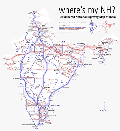
Rationalisation of Numbering system of national highways
All national highways in India are rationalised based on the US Highway numbering system. All highways are numbered based on their orientation from North to South and from East to West directions. Highways which are running from north to south are given even numbers and those running in the east-west direction are given odd numbers.
The Primary National Highways which are in N-S and E-W directions are given double digits for better identification by commuters (from 1 to 99). The numbers of the Primary National Highways increase from N-S and E-W. The Secondary National Highways are given three digit numbers.
As per the new scheme, multiple highways are merged into one new Highway. After the renumbering single longest national highway is NH 44 which will run from Srinagar to Kaniyakumari. The shortest Highway is NH-36. The distance is 3.0 km only. Some popular highways are truncated into multiple segments like the Chennai-Bangalore Old Madras Road via Chitoor (NH4) becoming N48-N40-N73-N75.
 |
| Rationalisation of Numbering system of national highways |
http://dorth.gov.in/writereaddata/sublinkimages/finaldoc6143316640.pdf
http://www.flickr.com/photos/arunganesh/4996257774/
http://en.wikipedia.org/wiki/List_of_National_Highways_in_India#Rationalization_of_Highway_numbers


National Waterways of India
Inland Waterways Authority of India (IWAI) was created in 1986 for development and regulation of Inland Waterways for shipping and navigation. The Authority undertakes the development and maintenance of Inland Waterways.
National Waterway 1 :
National Waterway 1 :
Allahabad–Haldia stretch of the Ganges–Bhagirathi–Hooghly river system.
Estd = October 1986. Length = 1620 km
National Waterway 2
Sadiya — Dhubri stretch of Brahmaputra river.
Estd = September 1982. Length = 891 km
National Waterway 3
Kottapuram-Kollam stretch of the West Coast Canal, Champakara Canal and Udyogmandal Canal.
Estd = February 1993 Length = 205 km
National Waterway 4
Kakinada–Pondicherry stretch of Canals and the Kaluvelly Tank, Bhadrachalam – Rajahmundry stretch of River Godavari and Wazirabad – Vijayawada stretch of River Krishna.
Estd = November 2008 Length = 1095 km
National Waterway 5
Talcher–Dhamra stretch of the Brahmani River, the Geonkhali - Charbatia stretch of the East Coast Canal, the Charbatia–Dhamra stretch of Matai river and the Mangalgadi - Paradip stretch of the Mahanadi River Delta.
Established = November 2008 Length = 623 km
Estd = October 1986. Length = 1620 km
National Waterway 2
Sadiya — Dhubri stretch of Brahmaputra river.
Estd = September 1982. Length = 891 km
National Waterway 3
Kottapuram-Kollam stretch of the West Coast Canal, Champakara Canal and Udyogmandal Canal.
Estd = February 1993 Length = 205 km
National Waterway 4
Kakinada–Pondicherry stretch of Canals and the Kaluvelly Tank, Bhadrachalam – Rajahmundry stretch of River Godavari and Wazirabad – Vijayawada stretch of River Krishna.
Estd = November 2008 Length = 1095 km
National Waterway 5
Talcher–Dhamra stretch of the Brahmani River, the Geonkhali - Charbatia stretch of the East Coast Canal, the Charbatia–Dhamra stretch of Matai river and the Mangalgadi - Paradip stretch of the Mahanadi River Delta.
Established = November 2008 Length = 623 km

Source : http://www.iwai.nic.in/index1.php?lang=1&level=1&sublinkid=124&lid=143


Physical Features Map of India
 |
| Physical Features Map of india |
Some important archaeological sites in India
 |
| Some important archaeological sites in India |
Bhimbetka (in present-day Madhya Pradesh).Some sites, known as habitation sites, are places where people lived. These include caves and rock shelters such as the one shown here. People chose these natural caves because they provided shelter from the rain, heat and wind. Natural caves and rock shelters are found in the Vindhyas and the Deccan plateau. These rock shelters are close to the Narmada valley.
Traces of ash have been found in Kurnool caves. This suggests that people were familiar with the use of fire.
A number of early Palaeolithic sites were found at Hungsi. At some sites, a large number of tools, used for all sorts of activities, were found. These were probably
habitation-cum factory sites.
Subscribe to:
Posts (Atom)